Farm Assessments
Be Market Ready
Your Path to EUDR and AFi Compliance Starts Here
The new European Union Deforestation Free Beef Regulations (EUDR) and the Accountability Framework Initiative (AFi) are changing the global market. To protect your access to premium markets, prove your land stewardship, and be market-ready, you need a clear, verifiable record of your farm's deforestation status.
Welcome to the Cibo Labs Farm Assessment. Our unique process goes beyond a simple automated check to provide a comprehensive, credible assessment you can trust.
Our Unique Approach: The Power of Human Expertise
Unlike services that rely solely on automated data, our process is built on a crucial foundation: human interpretation and local ecological knowledge.
Here’s how our five-step process works:
1. Request an Assessment Log into your Cibo Labs dashboard to start. If you don't have an account, our team is ready to help you get started.
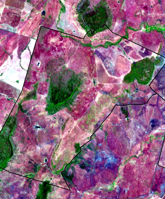
2. Our Detection Service We analyze your entire farm polygon—not just a single point—using a powerful combination of trusted data sources. This includes the Queensland Statewide Landcover and Trees Study (SLATS), NASA OPERA near-real-time alerts, and other national vegetation data.
3. Human Verification & Local Knowledge This is where our process is truly unique. If a potential woody vegetation change is detected, our Australian specialists—who understand local landscapes and land management practices—conduct a deeper analysis. We use additional high-resolution imagery and land-use mapping to assess the confidence of the finding.
4. Changes are Verified with You If desktop analysis results in low confidence, we don't just stop there. An assessor will contact you directly to discuss the findings. You'll have the opportunity to provide supplementary evidence, such as information on legal clearing, bushfires, or farm history, to increase the confidence in your farm's compliance.
5. You Receive a Full Report & Verifiable Credential Once the assessment is complete, you receive a detailed report with maps and clear explanations, along with a definitive risk assessment. This assessment is issued as an AgTrace-endorsed Verifiable Digital Credential, providing your supply chain partners with instant, secure, and verifiable proof of your deforestation-free status.
Why Choose Cibo Labs?
-
Credible, Human-Led Verification: We don't just rely on algorithms. Our specialists validate all changes, ensuring a fair and accurate assessment.
-
Local Expertise: Our Australian-based team understands the complexities of local landscapes, legislation, and land management practices.
-
Take Control: Our collaborative process gives you a voice in the assessment, allowing you to provide critical context and history.
-
Market-Ready: Receive a secure, digital credential that simplifies compliance and proves your commitment to land stewardship, protecting your access to vital global markets.
Ready to get started? Request an assessment through your Cibo dashboard account or register your interest and we'll send you instructions on how to get set up.
Register Your Interest In Farm Assessments
Cibo Labs Assessments Explained
-
What is the EUDR and how does it affect me?
The European Union Deforestation Regulation (EUDR) applies to all livestock-derived exports into the EU from December 30, 2025. To comply, you must prove that your property has not been subject to deforestation or forest degradation since December 31, 2020. This is a due diligence requirement for all beef exports to the EU.
-
Why should I act before December 31, 2025
Taking action now ensures you are supply chain-ready. Your agents, feedlots, and processors will soon need this documentation to buy or process your cattle for export. Early action proves you are compliant, building brand trust and securing future market access. Our service leverages the latest tools and provides a verifiable credential that goes beyond a simple geolocation check, preparing you for all EUDR requirements.
-
I heard Australia is considered a low-risk country under EUDR. Does this mean I don't need to do anything?No. While the European Commission recently classified Australia as a low-risk country, this does not eliminate the need for due diligence. The low-risk rating simplifies the process by reducing the number of annual audits from 3% to just 1% for EU importers. However, Australian producers and exporters are still required to provide geolocation data and other information on land use to EU importers to prove compliance.
.
-
Do I just need to provide a single point for the geolocation of my farm?
No, a single coordinate is not sufficient. Under the EUDR, geolocation data must accurately represent the entire production area. Specifically, for "plots" of land greater than 4 hectares, you must provide polygons (digital boundaries) that outline the entire area where the cattle were raised. This applies to all locations where the animals were kept from birth to slaughter. Our assessment platform is designed to handle and store this crucial polygon data for auditing purposes.
-
How does this assessment support the Integrity Systems Company (ISC) EU Voluntary ModuleOur assessment service aligns with and complements the ISC's initiative. We go further by assessing your entire farm polygon, not just a single center point. This ensures a comprehensive, post-to-post check that provides a higher level of assurance and a verifiable digital credential that is accepted by the supply chain.
-
What are the AFi/SBTi and why do they matter?
The Accountability Framework initiative (AFi) and Science Based Targets initiative (SBTi) are global frameworks that support deforestation-free claims and are increasingly required by major retailers and brands worldwide. Our assessment provides the verifiable data needed to meet the requirements of these frameworks, opening up market opportunities beyond the EU.
-
What if land on my property was cleared legally or by a natural event like fire or flood?
This is a key strength of our service. Our process allows you to provide supporting evidence for legal clearing or natural events. A trained assessor will then review this evidence against the EUDR and AFi standards